'Observation' Data-entry Form


1. Data-entry dialog (level-of-detail: standard):
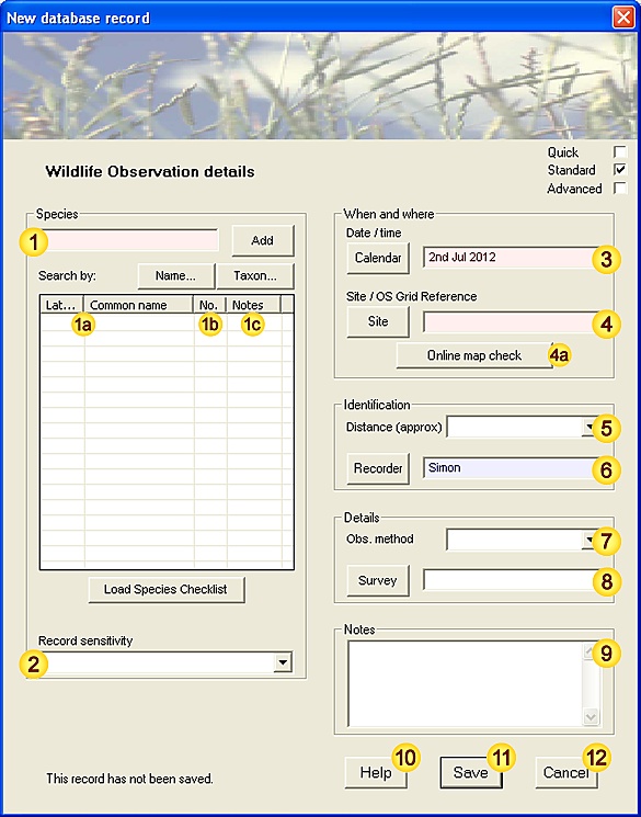
New Observation Form (level=standard)


2. Input fields - data description:

FieldNotes
SpeciesSpecies name (common or latin name).
See Species-data tool for a more detailed description of functionality.
Species entry(ies)These fields (Latin name / Common name) are auto-generated from field and may not be modified.
[Mandatory - this field must be completed.]
[Fixed-length field - 80 characters max.]
AbundanceThe total number of individuals seen (males+females+immature). This field will also recognise DAFOR abundance values.
When recording multiple species (ie. from a checklist), fields without abundance data will be ignored.
[Mandatory - this field must be completed.]
[When species are added individually, this field is preset to 1 for each species.]
[When species are added by checklist, this field is left blank allowing you to choose which species to record.]
NotesCan be used to provide additional species-related information (eg. sex(es), developmental stages, error estimates etc.).
[Free-text field - no maximum length.]
Record SensitivityA measure of the relative importance of this Observation, both in terms of national rarity status and personal considerations. This information allows you to manage sensitive records more easily, for example when exporting datasets.
Not sensitive Common species, where there is no forseeable need to restrict Observation data.
Notable Also known as 'Nationally Scarce'; these are species which occur in between
16 and 100 hectads of the Ordnance Survey National Grid.
Maybe BAP priority species BAP Priority species - the current list can be viewed by selecting the
Classifications | Protected Species list menu option.
In some cases BAP status is restricted to particular sub-species - where
sub-species identification is uncertain, 'Maybe BAP' status should be used.
BAP priority species
Rare Also known as 'Nationally Rare'; these are species which occur in 15 or fewer hectads
in the UK.
Confidential These settings allow you to flag particular Observations as personally important.
Top secret
Categories rank notionally in importance from lowest upwards. When an Observation is given 'Maybe BAP priority species' or 'BAP priority species' status, the species name is checked against the list of known BAP species for consistency.
[Fixed-length field - 28 characters max.]
Date / timeDate (and optionally time) of this Observation (see Note 3.1 for acceptable formats).
The Calendar button C allows you to select the date using the Calendar tool.
[Mandatory - this field must be completed.]
[This field is preset with the current date.]
LocationThe place where this Observation was made - may be either a Site name or a valid OS Grid reference.
[Mandatory - this field must be completed.]
[Fixed-length field - 80 characters max.]
Online checkDisplay the given location (Site or OS Grid reference), using an online map resource.
This tool requires an open internet connection.
DistanceEstimated distance between the recorder and species recorded. This information can provide a useful measure of confidence in unusual or confusing species.
[Values: <0.2m, 0.2-0.5m, 0.5-2m, 2-5m, 5-20m, 20-50m, 50-200m, 200-500m, 0.5-2km, 2-5km.]
RecorderThe person making the Observation.
[Advisory - this field should be completed wherever possible.]
[This field is preset with the name of the current user.]
[Fixed-length field - 32 characters max.]
Observation MethodThe means by which this species was encountered - incidental sighting or by various surveying techniques
[Values: Timed count, Timed max., Net sample, Species survey, Transect count, Area count, Quadrat, Volume count, Container sample, Baited Trap, Light Trap, Pitfall trap, Bait, Assembling, Pheromone lure, Other.]
[Fixed-length field - 32 characters max.]
SurveyThe Survey that this Observation relates to (if any).
[Fixed-length field - 80 characters max.]
NotesAny additional notes (double-click to resize).
[Free-text field - no maximum length.]

HelpView this help page.
SaveSave data as new record.
CancelCancel the form.


3. Additional Notes.

3.1. Input Date and Time formats

Any date / time format that is not ambiguous is acceptable, with few restrictions on separators. For example:

Acceptable Date / Time data formats
3 Sep 2006
3-Sep-2006
3:Sep:2006
ValidUnambiguous
3rd September 2006ValidUnambiguous
3 Sep 2006 2:10:00ValidUnambiguous
3/9/2006InvalidDay/Month order is ambiguous
[NB: 26/9/2006 is valid]
3 Sep 06InvalidDay/Year order is ambiguous
[NB: 3rd Sep 06 is valid]


'Survey' Data-entry Form


1. Data-entry dialog (level-of-detail: standard):

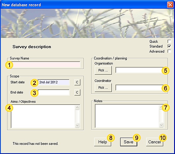
New Survey Form (level=standard)


2. Input fields - data description:

FieldNotes
SurveySurvey name.
[Mandatory - this field must be completed.]
[Fixed-length field - 80 characters max.]
Start dateSurvey start date (see Note 3.1 for acceptable formats).
The Calendar button C allows you to select the date using the Calendar tool.
[Advisory - this field should be completed wherever possible.]
[This field is preset with the current date.]
End dateSurvey end date (see Note 3.1 for acceptable formats).
The end date must not precede the Survey start date.
The Calendar button C allows you to select the date using the Calendar tool.
Aims / ObjectivesA brief summary of the intended scope (double-click to resize).
[Free-text field - no maximum length.]
OrganisationThe Organisation(s) and / or Association(s) leading the Survey.
[Free-text field - no maximum length.]
CoordinatorThe person coordinating the Survey efforts.
[Fixed-length field - 32 characters max.]
NotesAny additional notes (double-click to resize).
[Free-text field - no maximum length.]

HelpView this help page.
SaveSave data as new record.
CancelCancel the form.


3. Additional Notes.

3.1. Input Date and Time formats

Any date / time format that is not ambiguous is acceptable, with few restrictions on separators. For example:

Acceptable Date / Time data formats
3 Sep 2006
3-Sep-2006
3:Sep:2006
ValidUnambiguous
3rd September 2006ValidUnambiguous
3 Sep 2006 2:10:00ValidUnambiguous
3/9/2006InvalidDay/Month order is ambiguous
[NB: 26/9/2006 is valid]
3 Sep 06InvalidDay/Year order is ambiguous
[NB: 3rd Sep 06 is valid]


'Site' Data-entry Form


1. Data-entry dialog (level-of-detail: standard):

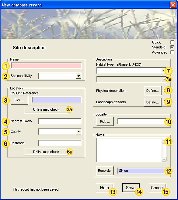
New Site Form (level=standard)


2. Input fields - data description:

FieldNotes
NameYour unique name for this Site.
[Mandatory - this field must be completed.]
[Fixed-length field - 80 characters max.]
Site SensitivityA measure of the relative importance of this Site, both in terms of nationally threatened habitats and personal considerations. This information allows you to manage sensitive records more easily, for example when exporting datasets.
Not sensitive Commonly occurring habitats, where there is no forseeable need to restrict
survey or locational information.
Slight risk from publication Unusual or notable habitats, which may be sensitive to excessive disturbance.
Maybe BAP priority habitat In some cases BAP status is unclear due to borderline or mosaic habitat types -
where classification is uncertain, 'Maybe BAP' status should be used.
The list of priority (BAP) habitats can be found by selecting the
Classifications | Protected Habitats list menu option.
BAP priority habitat
Sensitive to publication Rare habitats, which will attract and/or be significantly affected by disturbance.
Confidential These settings allow you to flag particular Sites as personally important.
Top secret
Categories rank notionally in importance from lowest upwards. Note, however, that priority habitats vary considerably in specificity; for example, compare Upland Birchwoods (NVC categories W4a,b; W11a-d; W17a,c,d only) with Rivers (all natural and near-natural running waters).
[Fixed-length field - 32 characters max.]
Review SensitivityDisplay Site classification and priority habitats information - this allows you to quickly substantiate the assigned Site sensitivity status.
OS Grid ReferenceRelevant OS grid reference.
[Advisory - this field should be completed wherever possible.]
[Fixed-length field - 16 characters max.]
Online map checkDisplay the given OS grid reference, using an online map resource.
This tool requires an open internet connection.
Nearest TownNearest Town or village to the Site.
(This information can be useful for cross-checking the Site location.)
[Fixed-length field - 32 characters max.]
CountyCounty in which the Site occurs.
[Fixed-length field - 32 characters max.]
PostcodePostcode area including or adjacent to the Site (if available).
(This information can be useful for cross-checking the Site location.)
[Fixed-length field - 16 characters max.]
Online map checkDisplay the given Postcode, using an online map resource.
This tool requires an open internet connection.
Habitat typePhase 1 habitat type for this Site (first-level categorisation) - see Note 3.1 for details.
[Values: Woodland and Scrub, Grassland, Tall herb and Fern, Heathland, Bog and Flush, Wetland (Swamp, marginal and inundation),
Open water, Coastland, Rock and waste, Miscellaneous (including urban), Marine.]

[Fixed-length field - 100 characters max. (combined first/second-level categories)]
Habitat typePhase 1 habitat type for this Site (second-level categorisation) - see Note 3.1 for details.
[Values depend on settings used in field ]
Physical DescriptionSupplementary fields for describing physical characteristics of the Site.
[Separate data-input form.]
Landscape artifactsSupplementary fields for describing Site artifacts.
[Separate data-input form.]
LocalityLocality(ies) in which this Site occurs.
[Free-text field - no maximum length.]
NotesAny additional notes (double-click to resize).
[Free-text field - no maximum length.]
RecorderThe person describing the Site.
[Advisory - this field should be completed wherever possible.]
[This field is preset with the name of the current user.]
[Fixed-length field - 32 characters max.]

HelpView this help page.
SaveSave data as new record.
CancelCancel the form.


3. Additional Notes.

3.1. Phase 1 habitat types

The Phase 1 Habitat Classification is a standardised system for recording semi-natural vegetation and other wildlife habitats, developed by JNCC, which provides a basic assessment of habitat type and potential importance for nature conservation. The classification system comprises ten (A-J) broad high level categories and a variable number of second and lower-level categorisations. FieldNotes uses only the two highest levels of the Phase 1 Habitat Classification system for describing sites (the lower level categories duplicate information provided by other site classification systems).

The Answers documentation includes a summary of the Phase 1 categories used in FieldNotes.

For a full description of the Phase 1 categories and associated field survey techniques see "Handbook for Phase 1 habitat survey - a technique for environmental audit" (ISBN: 0-86139-636-7), which may be purchased from JNCC and is also available as a free download from their website (pdf format).


'Site Detail' Data-entry Form


1. Data-entry dialog (level-of-detail: standard):

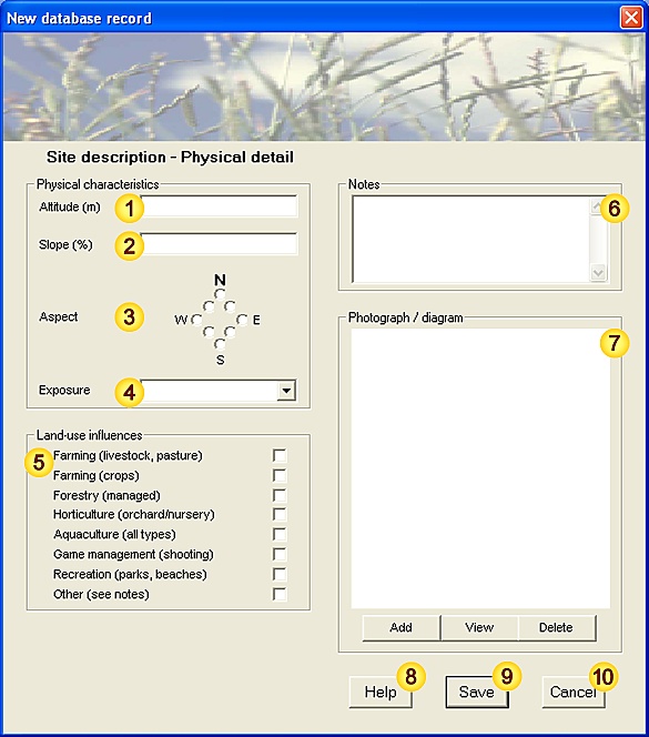
New Site Detail Form (level=standard)


2. Input fields - data description:

FieldNotes
AltitudeMean height above sea-level (metres).
[Fixed-length field - 1 decimal value.]
SlopeSlope, expressed as a percentage.
[Fixed-length field - 1 decimal value.]
AspectDirection in which the Site faces (if not level).
[Values: N, NE, E, SE, S, SW, W, NW.]
[Fixed-length field - 4 characters max.]
ExposureLocal topography / features that may shelter the Site.
[Values: Open, Open on three sides, Open on two sides, Open on one side, Hollow / depression, Enclosed, Cave / Tunnel.]
[Fixed-length field - 24 characters max.]
Land-use Influences(Primary land-management factors affecting the Site - select all that apply.
[Values: Farming (livestock, pasture), Farming (crops), Forestry (managed), Horticulture (orchard/nursery), Aquaculture (all types), Game management (shooting), Recreation (parks, beaches), Other.]
NotesAny additional notes (double-click to resize).
[Free-text field - no maximum length.]
Photograph / diagramPhotograph, map or diagram of the Site.
[JPEG / bitmap format.]

HelpView this help page.
SaveSave data as new record.
CancelCancel the form.


3. Additional Notes.

This form is used for supplementary information - there are no mandatory or advisory fields.


No measure of shading is included in the physical site details, as this is a very size-dependent factor (consider seedlings and mature trees). Sward, scrub and canopy cover (Site vegetation fields) provide indirect indices of shading.


'Site description - Landscape Artifacts' Data-entry Form


1. Data-entry dialog (level-of-detail: standard):

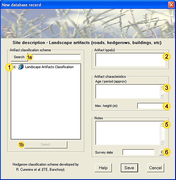
New Site description - Landscape Artifacts Form (level=advanced)


2. Input fields - data description:

FieldNotes
Artifacts Classification schemeA list of recognised Artifact types, systematically arranged in a hierarchial tree
(Landscape Artifacts classification scheme - see Note 3.1).
The classification scheme is represented by:
  • Artifact groups (), which form the higher levels of the classification tree,
    contain functionally-related sub-groups or artifact types.
  • Artifact types (), which occupy the lowest levels of the classification tree,
    represent indivisible artifact types.
Click on the '[+]' symbol to the left of an Artifact group name to expand its sub-types.
[SDR display field - no stored data.]
Search Artifact typesSearch the Artifact Classification scheme by entering a name (or part of a name) in the space provided
and using the Search button to locate matching category names.
[Categories are searched in a forward direction from the current position - press Search repeatedly
to cycle sequentially through all occurrences of the search term in the classification scheme .]
Select Artifact typeThis button adds the selected Artifact type or group (in the Artifacts Classification scheme) to the list
of Artifacts at this Site (field ). Certain high-level Artifact groups may not be selected, as these
are considered too generic to provide useful habitat information.
[Categories in the classification system may also be selected by double-clicking on the name.]
Artifact type(s)A list of artifact types that occur at this Site (selected from the classification scheme: field ).
There is no restriction on the number of artifact types that may be included.
[Items in this field are not directly editable, but may be removed using the Delete keyboard key.]
Artifact age / periodEstimated age / period of artifacts occurring at this Site.
[Free-text field - no maximum length.]
Artifact heightApproximate height (m) of artifacts occurring at this Site.
[May be used to denote depth where required.]
[Fixed-length field - 1 decimal value.]
NotesAny additional notes (double-click to resize).
[Free-text field - no maximum length.]
Survey dateDate (and optionally time) of Site Artifacts survey (see Note 3.2 for acceptable formats).
The Calendar button C allows you to select the date using the Calendar tool.
[Fixed-length field - 1 date/time value.]

HelpView this help page.
SaveSave data as new record.
CancelCancel the form.


3. Additional Notes.

This form is used for supplementary information - there are no mandatory or advisory fields.

3.1. Artifacts Classification Scheme

The Artifacts Classification Scheme was developed by Green Man Software for classifying landscape artifacts commonly encountered in the UK countryside. It incorporates the Hedgerows Classification Scheme developed by Roger Cummins et al. (1992) at the Institute of Terrestrial Ecology (now Centre for Ecology and Hydrology) for hedges and hedge-bottom communities across the UK.

The Artifacts Classification Scheme comprises twelve major (top-level) groups and a variable number of second and lower-level categorisations, describing the diverse range of man-made structures or perturbations (from ancient monuments to modern transport systems) that may impact our natural environment. The classification allows unambiguous and informative formal names to be assigned and helps to place such constructions in a wider environmental context, facilitating (among other things) storage in environmental information systems and production of habitat maps.

A full description of the Artifacts Classification Scheme, and the classification scheme itself, are available on the FieldNotes website.

3.1.1. References and further Information

"Diversity in British Hedgerows"; Roger Cummins, Don French, Bob Bunce, David Howard and Colin Barr. ITE, Banchory. 1992. NERC / ITE Project T02071a1.
Centre for Ecology and Hydrology (http://www.ceh.ac.uk/) - research centre for Ecology and Hydrology.
Landscape Artifacts Classification Scheme - background, details and latest version of the Artifacts Classification scheme (ACS).

3.2. Input Date and Time formats

Any date / time format that is not ambiguous is acceptable, with few restrictions on separators. For example:

Acceptable Date / Time data formats
3 Sep 2006
3-Sep-2006
3:Sep:2006
ValidUnambiguous
3rd September 2006ValidUnambiguous
3 Sep 2006 2:10:00ValidUnambiguous
3/9/2006InvalidDay/Month order is ambiguous
[NB: 26/9/2006 is valid]
3 Sep 06InvalidDay/Year order is ambiguous
[NB: 3rd Sep 06 is valid]


'Locality' Data-entry Form


1. Data-entry dialog (level-of-detail: standard):

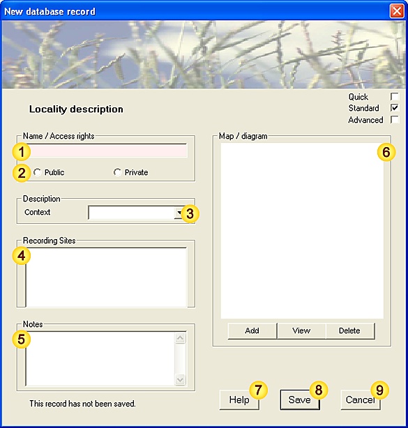
New Locality Form (level=standard)


2. Input fields - data description:

FieldNotes
NameA unique name for this Locality.
Where possible the Locality name should use an existing Ordnance Survey map feature name,
(eg. Predannack Downs, Polurrian cliffs) to allow cross-checking of associated Site locations.
[Mandatory - this field must be completed.]
[Fixed-length field - 80 characters max.]
AccessAccess rights to the Locality. (Public Access implies that no landowner permission is required to visit.)
[Values: Public, Private.]
[Fixed-length field - 12 characters max.]
ContextEnvironmental context - proximity to built-up or industrial areas.
[Values: Urban, Urban+Industrial, Suburban, Suburban+Industrial, Rural, Rural+Industrial, Remote, Remote+Industrial.]
[Fixed-length field - 20 characters max.]
SitesList of Sites within this Locality.
[This field is auto-populated.]
NotesAny additional notes (double-click to resize).
[Free-text field - no maximum length.]
Map / diagramMap / diagram of the Locality.
[JPEG / bitmap format.]

HelpView this help page.
SaveSave data as new record.
CancelCancel the form.


3. Additional Notes.

None.


'Contact' Data-entry Form


1. Data-entry dialog (level-of-detail: standard):

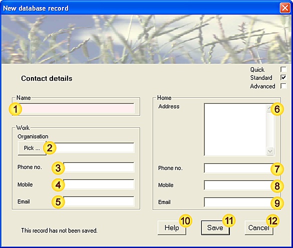
New Contact Form (level=standard)


2. Input fields - data description:

FieldNotes
NameContact's name.
[Mandatory - this field must be completed.]
[Fixed-length field - 32 characters max.]
OrganisationThe Organisation for which this person works.
[Fixed-length field - 80 characters max.]
Phone (work)Business phone number.
[Free-text field - no maximum length.]
Mobile (work)Business mobile number.
[Free-text field - no maximum length.]
Email (work)Business email address.
[Free-text field - no maximum length.]
AddressPostal address (outside working hours).
[Free-text field - no maximum length.]
PhonePhone number (outside working hours).
[Free-text field - no maximum length.]
MobileMobile number (outside working hours).
[Free-text field - no maximum length.]
EmailEmail address (outside working hours).
[Free-text field - no maximum length.]

HelpView this help page.
SaveSave data as new record.
CancelCancel the form.


3. Additional Notes.

3.1. Data Protection Act 1998

If you handle personal information about individuals, you have a number of legal obligations to protect that information under the Data Protection Act 1998. Please ensure that you are fully aware of your responsibilities and duties before entering Contact details.


'Recorder' Data-entry Form


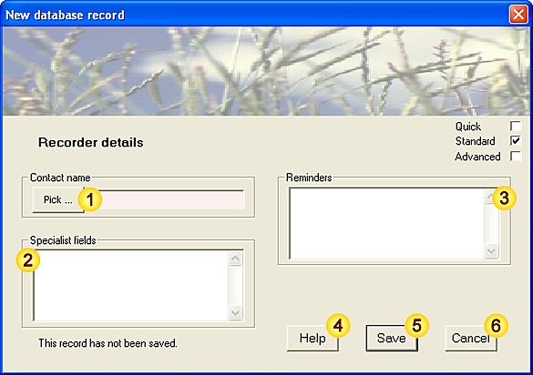
1. Data-entry dialog (level-of-detail: standard):

New Recorder Form (level=standard)


2. Input fields - data description:

FieldNotes
NameRecorder's name (Contact details).
[Mandatory - this field must be completed.]
[Fixed-length field - 32 characters max.]
Specialist fieldsAreas of expertise.
[Free-text field - no maximum length.]
RemindersAny other relevant information (double-click to resize).
[Free-text field - no maximum length.]

HelpView this help page.
SaveSave data as new record.
CancelCancel the form.


3. Additional Notes.

3.1. Data Protection Act 1998

If you handle personal information about individuals, you have a number of legal obligations to protect that information under the Data Protection Act 1998. Please ensure that you are fully aware of your responsibilities and duties before entering Recorder details.


'Organisation / Association' Data-entry Form


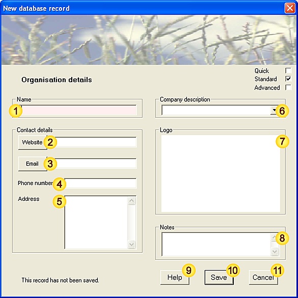
1. Data-entry dialog (level-of-detail: standard):

New Organisation Form (level=standard)


2. Input fields - data description:

FieldNotes
NameOrganisation name.
[Mandatory - this field must be completed.]
[Fixed-length field - 80 characters max.]
WebsiteWebsite address.
[Advisory - this field should be completed wherever possible.]
[Free-text field - no maximum length.]
EmailGeneral email address for enquiries.
This may be used for submitting datasets to relevant recording schemes.
[Advisory - this field should be completed wherever possible.]
[Free-text field - no maximum length.]
PhoneGeneral phone number for enquiries.
[Free-text field - no maximum length.]
AddressPostal address.
[Free-text field - no maximum length.]
DescriptionOne-line description of Organisation type.
[Values: Naturalists Society (general), Naturalists Society (fungi), Naturalists Society (lichens), Naturalists Society (plants), Naturalists Society (invertebrates), Naturalists Society (herptiles), Naturalists Society (birds), Naturalists Society (mammals), Naturalists Society (Conservation), Wildlife Trust, Biological Recorders Association, Local Records Centre (LRC), National Records Centre, Statutory / Public Body, Land-conservation body, Game Management Organisation, Information resource, Software and Data Specialists (Life-sciences), Other.]
LogoCompany logo.
[JPEG / bitmap format.]
NotesAny additional notes (double-click to resize).
[Free-text field - no maximum length.]

HelpView this help page.
SaveSave data as new record.
CancelCancel the form.


3. Additional Notes.

None.


'Checklist' Data-entry Form


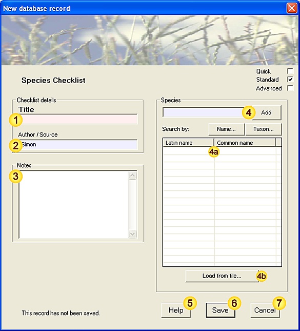
1. Data-entry dialog (level-of-detail: standard):

New Checklist Form (level=standard)


2. Input fields - data description:

FieldNotes
TitleChecklist Title (should be informative if possible, eg. My Local Moths).
[Mandatory - this field must be completed.]
[Fixed-length field - 80 characters max.]
Author / SourceOriginator - may be the author or a relevant organisation.
[Advisory - this field should be completed wherever possible.]
[This field is preset with the name of the current user.]
[Fixed-length field - 80 characters max.]
NotesAny additional notes, particularly significant inclusions or omissions (double-click to resize).
[Free-text field - no maximum length.]
SpeciesSpecies name (common or latin name).
[Mandatory - this field must be completed.]
[Free-text field - no maximum length.]
Checklist entry(ies)(auto-generated from field )
Load from FileLoad some or all Checklist entries directly from an external file.
[plain text (ascii) file; comma- or line-separated values]

HelpView this help page.
SaveSave data as new record.
CancelCancel the form.


3. Additional Notes.

None.


'Bibliography' Data-entry Form


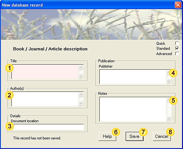
1. Data-entry dialog (level-of-detail: standard):

New Bibliography Form (level=standard)


2. Input fields - data description:

FieldNotes
TitleDocument title.
[Mandatory - this field must be completed.]
[Fixed-length field - 120 characters max.]
Author(s)Author details (relevant Organisation if relevant).
[Fixed-length field - 80 characters max.]
LocationLocation where the document is stored (eg. home, office, library)
[Free-text field - no maximum length.]
PublisherPublisher's details
[Free-text field - no maximum length.]
NotesAny additional notes (double-click to resize).
[Free-text field - no maximum length.]

HelpView this help page.
SaveSave data as new record.
CancelCancel the form.


3. Additional Notes.

None.