Using OS Grid references
Possibly the most difficult step in wildlife recording (once you recognise a handful of species) is the 'where' - establishing the unique OS Grid reference of the place where you made the observation.
Fortunately these days there are a number of electronic aids for both obtaining and checking grid references, from websites to GPS-enabled phones, which make the process much easier and less error-prone.
However there are still likely to be times when you need to refer directly to a paper map, either to read off or look up a location as a grid reference.
Working with OS Grid references
Before starting you will need ...
-
Large scale Ordnance Survey map (OS Explorer 1:25000 is good) covering the area of interest;
-
A ruler, pen and paper.
Optionally, if you have access to the internet there are a number of websites and tools that you can use to check your results.
This mini-tutorial aims to cover most aspects of working with OS Grid references.
The text is divided into the following four sections:
-
Understanding Grid references;
-
Working out the grid reference of a location;
-
Finding the map location from a Grid reference, and;
-
Notes about format and precision.
Note: The locations and maps shown here are for illustration only (you cannot look them up on UK maps), and are intended for use solely in the context of this document.
1. Understanding a Grid Reference
The three parts of a Grid Reference
Before working with grid references, it is important to understand their format and be able to separate out the 3 parts that they contain:
-
Grid square identifier (2 letters)
-
Eastings value (numbers)
-
Northings value (numbers)
Some parts of the Grid reference layout are always the same:
-
the Grid square identifier always consists of exactly two-letters
-
the 'eastings' value always has the same number of figures as the 'northings' value.
But some parts of the Grid reference are flexible, to allow them to be used in different ways:
-
the number of digits (eastings+northings) can vary in length (generally between 4 and 10 digits)
-
the Grid reference may include spaces between the separate parts, or may be written as a continuous string (depending on preference).
As a result there is no single 'correct' way of writing a grid reference, although the 6-figure grid reference (eg. SW 726 182) is probably the most widespread and suited to many requirements.
Anatomy of a 6-figure Grid Reference
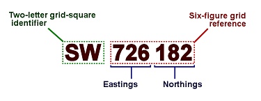
Note: Grid references are generally described by the total number of digits (ie. eastings+northings) that they contain.
For example, a 6-figure Grid reference is of the form: XX 123 456.
What do the parts of a Grid Reference mean?
The three parts of a grid reference contain sufficient information to identify any point within the UK grid area:
The Two-letter grid square identifier
The Ordnance Survey grid divides Great Britain into a series of 100km x 100km squares, each of which is given a two-letter code for quick reference.
The two-letter grid-square identifier shows which of the 100km grid squares the Grid reference refers to.
Understanding an OS Grid reference - the two-letter grid-square identifier
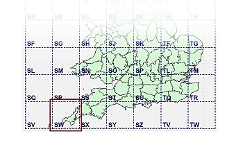
In the example used above (SW 726 182), the relevant grid square - SW - is near the bottom / left-hand corner of the map, covering West Cornwall.
Eastings and Northings values
The eastings and northings values (the first half and second half of the figures respectively) indicate how far east (towards the right) and north (towards the top) the point lies within the designated grid square.
To work out how far right or up the point is, the first figure in the Easting/Northing gives the relevant offset in 10ths of the whole grid-square, the next figure the additional offset in 10ths of each of the larger divisions, the next figure the additional offset in 10ths of a the preceding division, and so on.
For example,
Understanding an OS Grid reference - Eastings and Northings
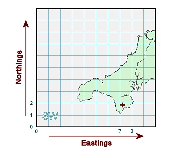
The approximate location of the point SW 726 182 (shown as '+') is:
-
between 7/10 and 8/10 east (right):
(ie. 7/10 + 2/100 + 6/1000, or 0.726 grid-squares right) and;
-
between 1/10 and 2/10 north (up):
(ie. 1/10 + 8/100 + 2/1000, or 0.182 grid-squares up)
in the SW grid square.
The effect of increasing or decreasing the number of digits in a Grid reference is described in more detail in Section 4 (below).
2. Working out the Grid Reference for a Location
This section describes the various methods for establishing the grid reference of a location - using maps and other means.
2(i). Working out the Grid Reference using a Map
Calculating a grid reference is relatively easy, consisting of three steps.
Identify the OS Grid square that the location is in.
The 2-letter code identifying the OS Grid square is given in large text at the bottom left-hand corner of the sheet.
Looking up the OS Grid-square

Some map sheets include parts of two (or more) adjacent OS Grid squares.
In these the secondary 2-letter code will be given at the Grid-square boundary (the point where the eastings/ northings restart from 00).
Work out the Eastings value for the location.
The eastings value (distance from the left of the grid-square) can be read off the top or bottom margin of the sheet, using the gridlines for reference.
Choose the gridline that is either directly on or immediately to the left of the location.
On OS Explorer Maps (1:25000 scale) the gridlines are labelled in 2-figures (00 - 99), which provide the first two digits of the Easting value
The third digit is obtained by calculating how far the location is to the right of the chosen gridline, using units of 1/10 of a grid-square.
Using a ruler (or romer) may help with this step.
Calculating the Eastings value

In this case:
-
the first two digits of the eastings value are '22' (gridline immediately to the left of the point).
-
the 3rd digit is '7' (the distance to the right of the gridline, in units of 1/10 grid-square).
Work out the Northings value for the location.
The northings value (distance from the bottom of the grid-square) is found in the same way, using the gridlines on the left or right margin of the sheet for reference.
Choose the gridline that is either directly on or immediately below of the location.
On OS Explorer Maps (1:25000 scale) the gridlines are labelled in 2-figures (00 - 99), which provide the first two digits of the Northing value
The third digit is obtained by calculating how far the location is above the chosen gridline, using units of 1/10 of a grid-square.
Calculating the Northing value
In this case:
-
the first two digits of the northings value are '09' (gridline immediately below the point).
-
the 3rd digit is '5' (the distance above the gridline, in units of 1/10 grid-square).
Put together the parts
The completed OS Grid reference is obtained by combining the OS grid square identifier, eastings and northings values (in that order):
The 6-figure Grid reference for this location:
SW 227 095
2(ii). Other methods of establishing the Grid Reference of a location
Hand-held GPS units
A number of hand-held GPS-enabled devices (including many mobile phones) can be used during fieldwork to display the OS grid reference of the current location.
The grid reference value is often supplied in to a very high resolution (8-figure or 10-figure format) - in some cases choosing a lower precision setting may be more relevant to recording requirements (see Section 4).
If your device will only display the latitude and longitude of the current location, use FieldNotes coordinate-conversion tool (menu: ) to translate values to the equivalent OS grid reference.
Online tools
A number of websites provide interactive tools that display the OS Grid reference of any selected point:
Online Grid reference lookup tools (in no particular order):
Generally the sites allow you to navigate within the map to the required location, then either create a marker at this point and lookup the associated map information, or give the Grid reference for the centre of the displayed map.
The exact mechanism varies from site to site and you may have to try a few to find one that suits your requirements.
3. Finding the Map Location from a Grid Reference
This section describes the various methods for finding the location that a Grid reference refers to - on either a paper or online map.
3(i). Finding the Location from a Grid Reference using a paper Map
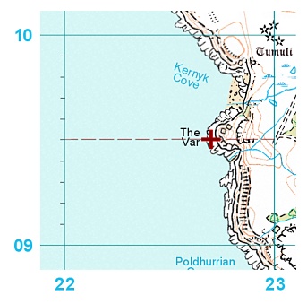
The first step in finding the location is to identify the three parts of the Grid reference - the two-letter Grid-square identifier, eastings value and northings value.
The two-letter grid-square identifier is self-evident.
The eastings and northings are obtained simply by splitting the figures into two parts of equal length.
Extracting location data from a Grid reference

Identify the relevant Map sheet
Two-letter Grid-square identifier indicates which OS grid-square, and hence which map, contains the location.
In some cases (where a Grid-square is split across several maps) you will also need to refer to the first two digits of the eastings and northings as well.
Identify the general region in which the location lies
Assuming that you have selected the correct map, look first at the eastings value to establish how far to the right (East) the location lies, then at the northings value to establish how far up (North) the location lies.
On larger-scale maps (eg. OS Explorer 1:25000 series), the first two digits of the eastings and northings correspond directly to the gridline labels.
Identify the general area of the location by moving right to match the first two digits of the eastings value, and up to match the first two digits of the northings value.
Finding the approximate location
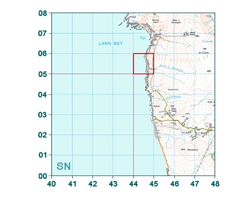
In this case:
-
the first two digits of the eastings value are '44' (this is the gridline immediately to the left of the point).
-
the first two digits of the northings value are '05' (this is the gridline immediately below the point).
This information allows you to highlight the area of the map (bounded by gridlines '44' - '45' horizontally, and gridlines '05' - '06' vertically) in which the point is located.
Identify the precise location of the Grid reference point
Next, identify the exact location by looking at the additional figures in the Easting/Northing values.
Finding the precise location
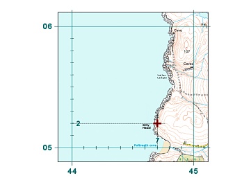
In this case:
-
the 3rd digit of the eastings value is '7' (this denotes the distance right of the '44' gridline, in units of 1/10 grid-square).
-
the 3rd digit of the northings value is '2' (this denotes the distance above the '05' gridline, in units of 1/10 grid-square).
>
The additional information allows you to locate the point quite precisely: in this case on the coast at Gilly Head.
3(ii). Finding the location of a Grid reference using Online map resources
FieldNotes includes a tool for resolving OS Grid references using online map resources (menu: ) and also from the 'Observations' and 'Site' data-entry forms .
This allows you to quickly check the location of any OS Grid reference in your browser.
Many (but by no means all) of the map-resource websites will display the location of a OS Grid reference, although they vary considerably in how easy it is to enter the relevant data.
Online Map resources which display Grid references (in no particular order):
The exact mechanism varies from site to site and you may have to try a few to find one that suits your requirements.
4. Precision - effects of varying the number of digits in a Grid reference
As the map square identified by the two-letter prefix is always a fixed size (100km x 100km), increasing the number of digits in the eastings and northings simply increases the precision with which the point is defined.
Each successive figure in the grid reference affects the precision of the designated point as follows:
Table 1. OS Grid reference values - precision associated with successive digits
| Easting/Northing value | Grid-square offset | Granularity |
first digit
(eg. AA 12345 12345) | Primary horizontal/vertical offset in units of 1/10 grid-square side | Increments are equivalent to 10km. |
second digit
(eg. AA 12345 12345) | Additional horizontal/vertical offset in units of 1/100 of a grid-square (ie. 10ths of each 10th) | Increments are equivalent to 1km. |
third digit
(eg. AA 12345 12345) | Additional horizontal/vertical offset in units of 1/1000 of a grid-square (ie. 10ths of each 100th) | Increments are equivalent to 100m. |
fourth digit
(eg. AA 12345 12345) | Additional horizontal/vertical offset in units of 1/10000 of a grid-square (ie. 10ths of each 1000th) | Increments are equivalent to 10m. |
fifth digit
(eg. AA 12345 12345) | Additional horizontal/vertical offset in units of 1/100000 of a grid-square (ie. 10ths of each 10000th) | Increments are equivalent to 1m. |
OS grid references are most usually given in six-figure format (eg. AA 123 123).
This level of precision resolves to a 100m-square on the ground, which is adequate for most applications.
However grid references can be specified to other levels of precision; for example, many GPS units and online mapping resources provide 8-figure or 10-figure OS grid references as standard.
Table 2. Applications of OS Grid reference values:
| Grid reference format | Resolution | Notes |
| four-figure (eg. AA 12 12) | 1km square | Low resolution; often sufficient for highly mobile species (eg. birds, marine species). |
| six-figure (eg. AA 123 123) | 100m square | Most widespread format; suitable for many uses. |
| eight-figure (eg. AA 1234 1234) | 10m square | High precision format; sometimes useful for static species of particular interest. |
| ten-figure (eg. AA 12345 12345) | 1m square | Ultra-high precision; generally exceeds everyday requirements. |
When reporting locations as OS grid references, the relevance of precision is often overlooked.
The number of figures that used in the grid reference convey important information about the precision with which the location is specified.
For example, consider the following grid references - are they all equivalent (ie. freely interchangeable)?
| SW 12 12 |
| SW 120 120 |
| SW 1200 1200 |
| SW 12000 12000 |
Although the four grid references refer to the same point, their format additionally indicates the confidence (ie. precision) with which they identify the location.
At the extreme ends of the scale, the lowest precision value (SW 12 12) refers to a 1km by 1km square surrounding the relevant point (see Table 1 above).
In contrast the highest precision value (SW 12000 12000) resolves the point with a precision of 1m by 1m.
Obviously the values are not directly equivalent, and some care should be taken in choosing the most appropriate format when reporting grid reference values.