The Ordnance Survey (OS) grid uses the best local mathematical projection to transform the region of Great Britain from a curved surface (the world sphere) to a flat plane (2d map) with minimal distortion. The grid applies the OSGB36 datum (Ordnance Survey Great Britain 1936) based on the Airy 1830 ellipsoid with a true origin of 49°N 2°W. Although the OS Grid theoetically extends to include Ireland and many countries Europe, grid references are only valid for Great Britain.
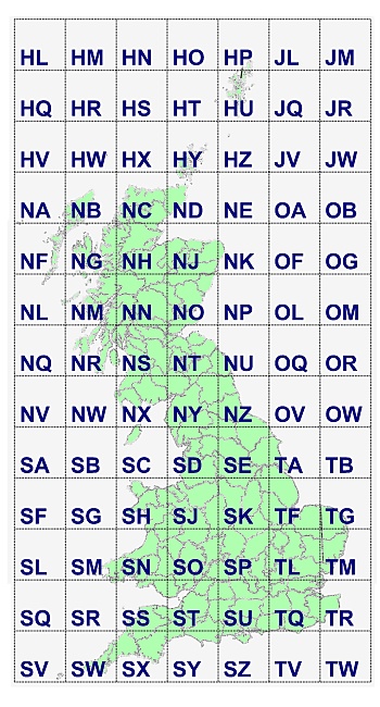
OS Grid squares
The GB map region is divided into a series of 100km squares, which are identified by unique 2-letter codes.
Notes.
The OS Grid theoretically extends beyond the bounds shown above; however these values are rarely used.
OS Grid references
When identifying a location (point) within the OS Grid region, the two-letter grid-square identifiers provide the first level of resolution. Additional precision is provided by eastings and northings - numerical offsets from the origin of each grid-square.
The main characteristics of Grid references, aswell as information on using them, are described elsewhere (Using OS Grid references) in the documentation.
Conversions with other Coordinate systems
The OS grid uses the OSGB36 datum to represent the shape of the earth. This is subtly different from the WGS84 datum used by most GPS devices, and requires particular care when translating coordinates between systems. FieldNotes coordinate-conversion tool (menu: ) can be used to apply a number of coordinate translations, including WGS84 / OSGB36.
References and additional information
Further information about the Ordnance Survey grid is available from their website: http://www.ordnancesurvey.co.uk/.