The Species database
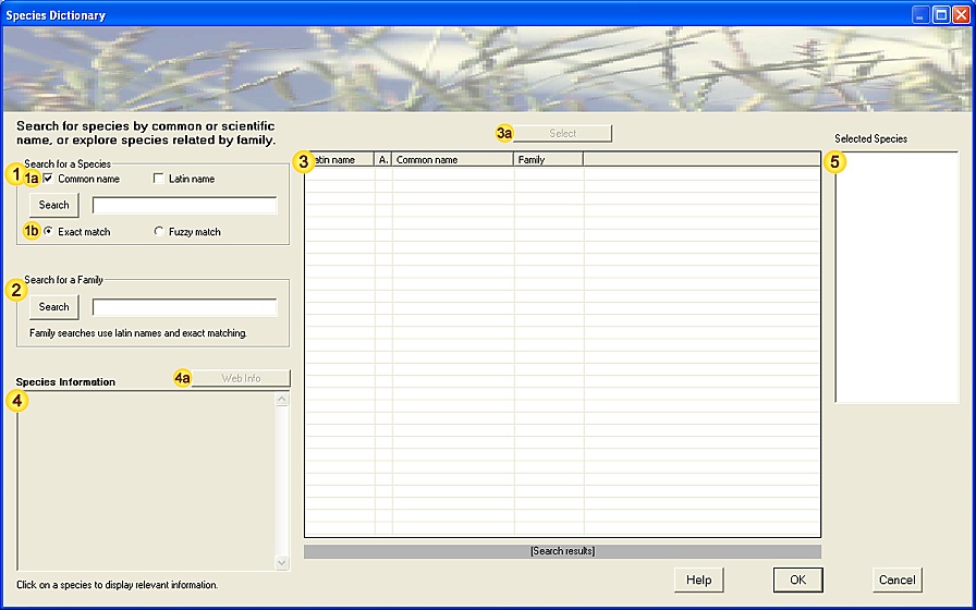
1. The Species database form:
2. Species database tools:
| Field | Notes |
| Species name search | Search for matching Species - enter the search text (species name) in the space provided and press the Search button.
The search text does not need to be a complete species name - for example:
-
searching for "elephant" (by common name) will list all species which include "elephant" as part of their name [5 matches].
-
searching for "euphrasia" (by scientific name) will list all species which include "euphrasia" as part of their name [92 matches].
Each separate word in the search text is matched - for example:
-
searching for "purple emperor" (by common name) will list all species which include either "purple" or "emperor" in their name [103 matches].
For a brief description of species names' etymology see Note 3.1.
For a brief summary of the search algorithm see Note 3.2. |
| Search type | Specify field to be searched - Common or Latin (scientific) names. |
| Search method | Specify method of searching - exact or fuzzy matching.
-
Exact matching will only show species names that precisely match any word the search text.
-
Fuzzy matching will additionally show species names that are broadly similar to the search text
(for example, those that contain missing or transposed letters), but as a result will return many more hits.
|
| Family search | Search for species within a particular family - enter the search text (family name) in the space provided and press the Search button.
Family searches use Latin (scientific) family names and exact matching.
Only one family name can be searched at any time. |
| Search results | List of species that either:
-
match one or more words in the specified search text (species name searches).
-
belong to the named family (family searches).
Select a species from the list (by clicking on it) to display full species information (Field ). |
| Select species | Add highlighted species (from Field ) to the list of selected species (Field ). |
| Species information | Detailed taxonomic and conservation information about the highlighted Species in the list of search results (Field ).
[Preferred Scientific and Common names; authority; alternative Scientific and Common names; UK status;
Conservation status; NBN key and Taxonomic information.] |
| Web-based species information | Lookup additional web-based resources for this species.
The web-lookup requires an open internet connection. |
| Selected species | Species selected from the list of search results (Field ).
When the form is being used as a Species lookup tool, these values are returned from the dialog on exit.
When the form is simply being used to explore Species names, these values are retained for reference only. |
|
| Help | View this help page. |
| OK | Close the dialog. |
| Cancel | Cancel the form. |
3. Additional Notes.
3.1. Species Names
Why name species?
Simply by naming objects, we are able to do a number of useful things; from communicating information about them, through comparing and recording them, to more esoteric concepts such as classifying them.
Most commonly encountered species have a number of names which fall into two groups; everyday (common) names and scientific (latin) names.
3.1.1. Common names
The everyday names that we use for animals, plants and fungi form a rich part of our heritage.
Their early origins are often uncertain, being deeply rooted in language development, herbal knowledge and folklore.
However a scan through any species list will emphasise their vivid imagery - it is difficult to forget the name of an Orange Tip butterfly or Snakelocks anemone after your first encounter.
3.1.2. Scientific names
All recognised species are given a unique scientific name, based on the binomial classification system pioneered by Linnaeus.
Species names have two components: the group (genus) to which the species belongs and specific name (epithet).
For example, Quercus alba (White Oak); Quercus is the genus name for oaks, alba (latin for 'white') describes one particular type (species) of oak.
Scientific names are always written according to a strict convention: the genus is capitalised and the specific epithet is lowercase.
Both components must be used when describing species (although genus may be abbreviated to a single letter after first use).
Scientific names are also generally italicised or underlined.
eg.
-
Lepus timidus - Mountain or Snow Hare
-
Mycena adonis - Coral-pink Bonnet fungus
-
Colias croceus - Clouded Yellow butterfly
Scientific names are occasionally updated, for example when new evidence shows that a species does not belong in the genus to which it was originally assigned.
eg.
-
Painted Lady butterfly - Vanessa cardui (previously Cynthia cardui)
In such cases the species is given a new (preferred) scientific name; however existing literature will continue to describe the species by its original name - this therefore remains relevant to understanding the complete description of the species.
3.1.3. References and further Information
Naming Species - UK Species website (Green Man Software).
3.2. Species-name search algorithm
This section briefly summarises the different methods used to search the species database - understanding the steps (algorithms) involved may allow you to use the tools more effectively.
3.2.1. Exact match algorithm
In the exact match algorithm, the search text is divided into words (separated by spaces) and each word used as a separate search term.
This allows you to use fairly generic searches (for example when you can only remember part of a name) and sort through the results to find the appropriate species:
|
Searching for "mouse hawkweed" will return more than 300 matches - Mouse-ear Hawkweed (ranked first) is the most likely candidate.
|
In both common name and latin name searches, the preferred name and any alternative names are searched.
This ensures that the relevant species is easily identified, even when scientific names have been updated or a species is known by different common names locally.
Example 1. (Common name search)
Searching for "Throttle-wort" will identify "Foxglove" as the best match (more widespread common name).
|
Example 2. (Latin name search)
Searching for "Rana esculenta" will identify "Pelophylax esculentus" as the best match (updated scientific name).
|
Finally the search results are ranked by relevance, primarily by the closeness of matching (but also by several other factors).
|
Searching for "Bright-line Brown-eye" will rank results in order: "Bright-line Brown-eye", "Brown-line Bright-eye", "Clear-eye", etc.
|
3.2.2. Fuzzy match algorithm
The fuzzy match algorithm uses a slightly different approach, matching the entire search text directly against each of the species names and checking for correspondence.
This method will match approximations to a name (particularly useful for scientific names), repeated or missing letters, transpositions and other similar errors.
As a result searches using fuzzy matching will generally return many more hits than those using exact matching.
Example 1. (Common name search)
Searching for "Redneck Phallarope" will identify "Red-necked Phalarope" as a potential match (alongside others).
|
Example 2. (Latin name search)
Searching for "Vipera beris" will identify "Vipera berus" as a possible match (common spelling mistake).
|
Again the search results are ranked by relevance, primarily by the closeness of correspondence with the original search text.
As for exact match searches, the matching algorithm examines the preferred and alternative names.
3.2.3. Family search algorithm
The family name search uses the exact matching algorithm (see section 3.1.1) with the simplification of only matching a single word.
The Taxon database
(Taxonomic Classification scheme)
1. The Taxon database form:
2. Taxon database tools:
| Field | Notes |
| 'Tree of life'
classification scheme | A list of recognised taxonomic groups (see Note 3.1), systematically arranged in a hierarchial tree.
The classification scheme is represented by:
-
High-level taxonomic groups (
 ), eg. Kingdom, Phylum, Class, Order (and related super- and sub-components), ), eg. Kingdom, Phylum, Class, Order (and related super- and sub-components),
which form the higher levels of the classification tree.
-
Families (
 ), which occupy the lowest levels of the classification tree and contain related species. ), which occupy the lowest levels of the classification tree and contain related species.
Click on the '[+]' symbol to the left of a group name to expand its sub-groups or list its component species. |
| Search 'Tree of life'
classification scheme | Search the Taxonomic classification by entering a name (or part of a name) in the space provided
and using the Search button to locate matching category names.
[Categories are searched in a forward direction from the current position - press Search repeatedly
to cycle sequentially through all occurrences of the search text in the classification scheme.] |
| Taxon information | Summary information about the currently selected Taxon group (in Field ).
Taxon information includes taxonomic status, preferred / alternative common and scientific names, brief description, etc. |
| Species list | List of species that occur in a specified Family group (ie. selected in Field ).
[Certain families, for example many single-celled organisms, do not have any listed species -
these are in the process of being added to the species database.] |
| Select species | Add highlighted species (from Field ) to the list of selected species (Field ). |
| Selected species | Species selected from the family-based list (Field ).
When the form is being used as a Species lookup tool, these values are returned from the dialog on exit.
When the form is simply being used to explore taxonomic relationships, these values are retained for reference only. |
|
| Help | View this help page. |
| OK | Close the dialog. |
| Cancel | Cancel the form. |
3. Additional Notes.
3.1. Taxonomic Classification
Organisms are grouped (classified) by comparing structural (and more recently genetic) similarities, and using these to arrange species according to common ancestry.
Several alternative classification schemes exist, based on different interpretations of these relationships; indeed classification systems are fairly frequently revised, particularly as a result of the extraordinary advances in molecular and DNA studies in recent years.
One commonly used classification scheme is:
|
Kingdom
|
Five kingdoms are usually recognised (Protoctista,Monera,Fungi,Plants,Animals)
|
|
Phylum
|
This is termed Division in the plant kingdom.
|
|
Class
|
|
|
Order
|
|
|
Family
|
Highest group commonly used in Species classification (generally small enough to distinguish members).
Family names for animals end in -idae, for plants in -aceae.
|
|
Genus
|
Highest group directly referred in scientific name.
|
|
Species
|
Epithet in scientific name.
|
|
Subspecies, Varieties, Forms, etc
|
All groups below Species will interbreed if isolating factors are removed.
|
A number of further taxonomic sub-divisions (eg. superfamily, suborder, tribe) may be used
to denote finer-scale groupings.
3.1.1. References and further Information
The Need for Classification Anonymous.
The Geology Classification scheme
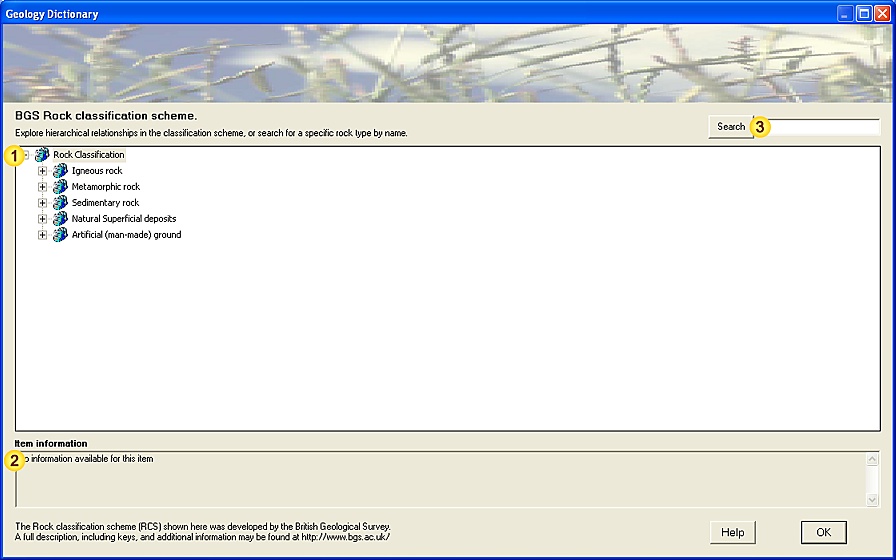
1. The Geology classification scheme form:
2. Geology classification scheme tools:
| Field | Notes |
| Rock Classification scheme | A list of recognised Rock types, systematically arranged in a hierarchial tree
(British Geological Survey classification scheme - see Note 3.1).
The classification scheme is represented by:
-
Rock groups (), which form the higher levels of the classification tree,
contain geologically-similar sub-groups or rock-types.
-
Rock types (
 ), which occupy the lowest levels of the classification tree, ), which occupy the lowest levels of the classification tree,
represent indivisible types.
Click on the '[+]' symbol to the left of a Rock group name to expand its sub-types. |
| Item information | Relevant information about the selected Rock type or group. |
| Search Rock types | Search the Rock Classification scheme by entering a name (or part of a name) in the space provided
and using the Search button to locate matching category names.
[Categories are searched in a forward direction from the current position - press Search repeatedly
to cycle sequentially through all occurrences of the search text in the classification scheme.] |
|
| Help | View this help page. |
| OK | Close the dialog. |
3. Additional Notes.
3.1. Rock Classification Scheme
The Rock Classification Scheme used here is developed the British Geological Survey, and provides a standardised system for classifying and naming geological materials encountered in the UK.
The BGS Rock Classification Scheme comprises five top-level categories (Igneous rock, Metamorphic rock, Sediments and sedimentary rock, Natural superficial deposits and Artifical man-made ground) and a variable number of second and lower-level categorisations.
The classification allows unambiguous and informative formal names to be assigned and helps to place materials in a wider geological context, facilitating (among other things) storage in geological information systems and production of geological maps.
Details of the principles behind the BGS Rock Classification Scheme (RCS), the classification scheme itself and a wealth of associated geological information is available on the British Geological Survey website, or by contacting the British Geological Survey at Keyworth.
3.1.1. References and further Information
BGS Rock Classification Scheme (http://www.bgs.ac.uk/bgsrcs/) - background, details and latest version of the British Geological Survey's Rock Classification scheme (RCS).
British Geological Survey (http://www.bgs.ac.uk/) - research centre for Geological Sciences at Keyworth, Notts.
The Soil Classification scheme
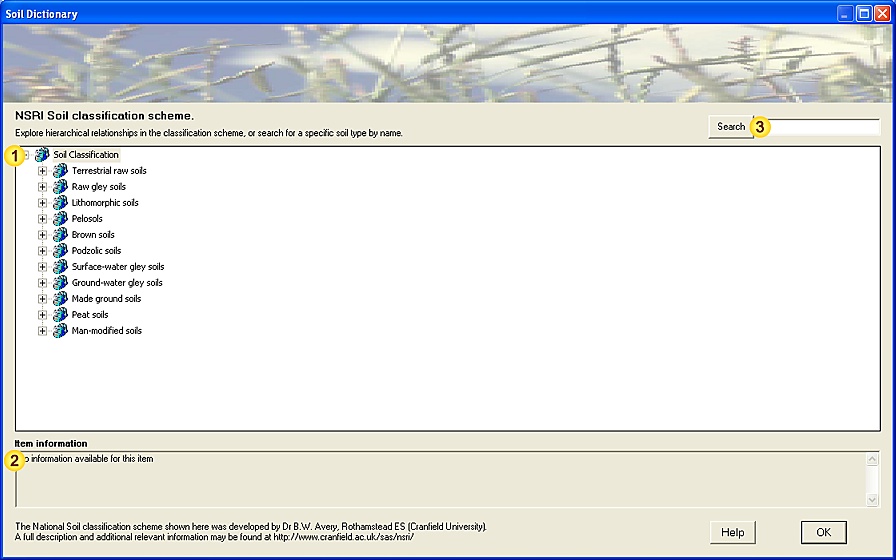
1. The Soil classification scheme form:
2. Soil classification scheme tools:
| Field | Notes |
| Soil Classification scheme | A list of recognised Soil types, systematically arranged in a hierarchial tree
(National Soil Survey classification scheme - see Note 3.1).
The classification scheme is represented by:
-
Soil groups (), which form the higher levels of the classification tree,
contain similar sub-groups or soil-types.
-
Soil types (
 ), which occupy the lowest levels of the classification tree, ), which occupy the lowest levels of the classification tree,
represent indivisible types.
Click on the '[+]' symbol to the left of a Soil group name to expand its sub-types. |
| Item information | Relevant information about the selected Soil type or group. |
| Search Soil types | Search the Soil Classification scheme by entering a name (or part of a name) in the space provided
and using the Search button to locate matching category names.
[Categories are searched in a forward direction from the current position - press Search repeatedly
to cycle sequentially through all occurrences of the search text in the classification scheme.] |
|
| Help | View this help page. |
| OK | Close the dialog. |
3. Additional Notes.
3.1. Soil Classification Scheme
The Soil Classification Scheme used here was originally developed for the National Soil Survey of England and Wales at Rothamstead Experimental Station ("Soil Classification for England and Wales [Higher Categories]." B.W. Avery. 1980.).
The classification scheme was later extended by National Soil Resources Institute (Cranfield University) to include more urban and man-made soil types, and provides the standardised system for classifying and naming soil types of England and Wales. (In Scotland an alternative classification system is often used, due to the marked differences in soil types in this region.)
The NSRI Soil Classification Scheme comprises eleven major (top-level) groups and a variable number of second and lower-level categorisations.
The classification scheme shown here incorporates the higher level categories only.
The classification allows unambiguous and informative formal names to be assigned and helps to place materials in a wider environmental context, facilitating (among other things) storage in environmental information systems and production of soil maps.
A full description of the NSRI Soil Classification Scheme, the classification scheme itself and a wealth of soil-related information is available on the National Soil Resources Institute website, or by contacting the National Soil Resources Institute at Cranfield University.
3.1.1. References and further Information
"Soil Classification for England and Wales [Higher Categories]." B.W. Avery. 1980. Soil Survey - Technical Monograph No. 14. Harpendon.
National Soil Resources Institute (http://www.cranfield.ac.uk/sas/nsri/) - research centre for Soil Science at Cranfield University.
Soil-Net (http://www.soil-net.com/) - An extensive Internet resource providing information about Soils, developed by National Soil Resources Institute.
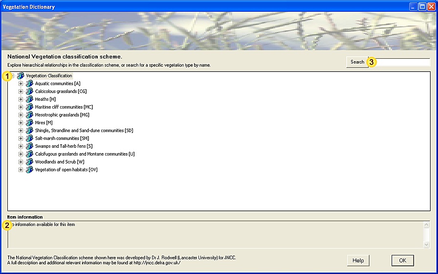
The Vegetation Classification scheme
1. The Vegetation classification scheme form:
2. Vegetation classification scheme tools:
| Field | Notes |
| Vegetation Classification scheme | A list of recognised Vegetation types, systematically arranged in a hierarchial tree
(National Vegetation Classification scheme - see Note 3.1).
The classification scheme is represented by:
-
Vegetation groups (), which form the higher levels of the classification tree,
contain similar sub-groups or vegetation-types.
-
Vegetation types (
 ), which occupy the lowest levels of the classification tree, ), which occupy the lowest levels of the classification tree,
represent indivisible types.
Click on the '[+]' symbol to the left of a Vegetation group name to expand its sub-types. |
| Item information | Relevant information about the selected Vegetation type or group. |
| Search Vegetation types | Search the Vegetation Classification scheme by entering a name (or part of a name) in the space provided
and using the Search button to locate matching category names.
[Categories are searched in a forward direction from the current position - press Search repeatedly
to cycle sequentially through all occurrences of the search text in the classification scheme.] |
|
| Help | View this help page. |
| OK | Close the dialog. |
3. Additional Notes.
3.1. National Vegetation Classification Scheme
The National Vegetation Classification Scheme used here was developed by Dr J. Rodwell (Unit of Vegetation Science, Lancaster University) for the Joint Nature Conservation Committee, and provides a standardised system for classifying and naming vegetation community types encountered in the UK.
The National Vegetation Classification scheme is a 'phytosociological' classification - classifying vegetation solely by the component plant species.
The Vegetation Classification Scheme comprises twelve major vegetation types (which are denoted by letter codes) and a variable number of community and sub-community categorisations.
The classification allows unambiguous and informative formal names to be assigned and helps to place vegetation communities in a wider environmental context, facilitating (among other things) storage in environmental information systems and production of vegetation maps.
A full description of the National Vegetation Classification scheme, the classification scheme itself and a wealth of related information is available on the JNCC website, or by contacting the Joint Nature Conservation Committee at Peterborough.
3.1.1. References and further Information
"British Plant Communities. Volume 1. Woodlands and scrub." Rodwell, J.S. (ed.) 1991. Cambridge University Press.
"British Plant Communities. Volume 2. Mires and heath." Rodwell, J.S. (ed.) 1991. Cambridge University Press.
"British Plant Communities. Volume 3. Grassland and montane communities." Rodwell, J. S. (ed.) 1992. Cambridge University Press.
"British Plant Communities. Volume 4. Aquatic communities, swamps and tall-herb fens." Rodwell, J.S. (ed.) 1995. Cambridge University Press.
"British plant communities. Volume 5. Maritime communities and vegetation of open habitats." Rodwell, J.S. (ed.) 2000. Cambridge University Press.
"National Vegetation Classification: User's handbook."; John S. Rodwell. 2006. JNCC Publications (ISBN: 0-86139-636-7).
This publication is also available as a free download from the Joint Nature Conservation Committee (JNCC) website (pdf format).
"Review of coverage of the National Vegetation Classification." Rodwell, J.S., et al. 2000. Joint Nature Conservation Committee Report No. 302.
Rodwell, J.
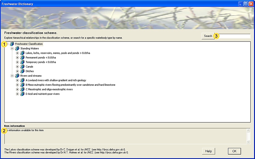
The Freshwater Classification scheme
1. The Freshwater classification scheme form:
2. Freshwater classification scheme tools:
| Field | Notes |
| Freshwater Classification scheme | A list of recognised freshwater categories and community types, systematically arranged in a hierarchial tree
(Standing waters, Rivers and Streams classification scheme - see Note 3.1).
The classification scheme is represented by:
-
Freshwater groups (), which form the higher levels of the classification tree,
contain similar sub-groups or freshwater community types.
-
Freshwater types (
 ), which occupy the lowest levels of the classification tree, ), which occupy the lowest levels of the classification tree,
represent indivisible community types.
Click on the '[+]' symbol to the left of a Freshwater group name to expand its sub-types. |
| Item information | Relevant information about the selected Freshwater community type or group. |
| Search Freshwater types | Search the Freshwater Classification scheme by entering a name (or part of a name) in the space provided
and using the Search button to locate matching category names.
[Categories are searched in a forward direction from the current position - press Search repeatedly
to cycle sequentially through all occurrences of the search text in the classification scheme.] |
|
| Help | View this help page. |
| OK | Close the dialog. |
3. Additional Notes.
A number of schemes have been developed to describe characteristics of flowing and static waterbodies in the UK.
Two separate classification schemes are used here:
'The Vegetation communities of British lakes: a revised classification', developed by Dr C. Duigan et al. (2006) for the Joint Nature Conservation Committee, provides a standardised system for classifying and naming vegetation community types encountered in standing waters (lakes and pools) in the UK.
The revised lakes classification scheme comprises ten major (top-level) groups (A-J), and a single second-level categorisation.
'The Vegetation communities of British rivers - a revised classification' was developed by Dr N. Holmes et al. (1999) for the Joint Nature Conservation Committee, and provides a standardised system for classifying and naming vegetation community types encountered in rivers and streams in the UK.
The revised British rivers and streams Classification scheme comprises four major groups (A-D), which in turn are split into a number of types and sub-types.
The two classifications allow unambiguous and informative formal names to be assigned and helps to place waterbodies in a wider environmental context, facilitating (among other things) storage in environmental information systems and production of maps.
A full description of both the lakes and rivers/streams classification schemes, the classification schemes themself and a wealth of related information about freshwater classifications are available on the JNCC website, or by contacting the Joint Nature Conservation Committee at Peterborough.
At the present time there is no robust classification system for canals and small ponds (<0.01ha).
3.1.1. References and further Information
"Vegetation communities of British lakes: a revised classification." Duigan CA, Kovach WL, and Palmer M. 2006. JNCC Publications.
"Vegetation communities of British rivers - a revised classification." Holmes, N.T, Boon, P.J., and Rowell, T.A. 1999. JNCC Publications.
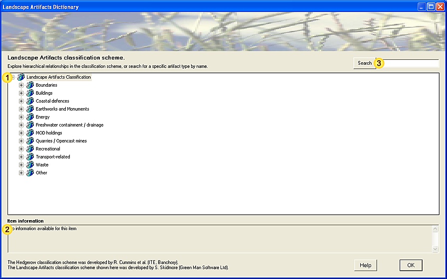
The Landscape Artifacts Classification scheme
1. The Artifact classification scheme form:
2. Artifact classification scheme tools:
| Field | Notes |
| Artifacts Classification scheme | A list of recognised Artifact types, systematically arranged in a hierarchial tree
(Landscape Artifacts classification scheme - see Note 3.1).
The classification scheme is represented by:
-
Artifact groups (), which form the higher levels of the classification tree,
contain functionally-related sub-groups or artifact types.
-
Artifact types (
 ), which occupy the lowest levels of the classification tree, ), which occupy the lowest levels of the classification tree,
represent indivisible artifact types.
Click on the '[+]' symbol to the left of an Artifact group name to expand its sub-types. |
| Item information | Relevant information about the selected Artifact type or group. |
| Search Artifact types | Search the Artifact Classification scheme by entering a name (or part of a name) in the space provided
and using the Search button to locate matching category names.
[Categories are searched in a forward direction from the current position - press Search repeatedly
to cycle sequentially through all occurrences of the search text in the classification scheme.] |
|
| Help | View this help page. |
| OK | Close the dialog. |
3. Additional Notes.
3.1. Artifacts Classification Scheme
The Artifacts Classification Scheme used here was developed by Green Man Software Ltd for classifying landscape artifacts commonly encountered in the UK countryside.
It incorporates the Hedgerows Classification Scheme developed by Roger Cummins et al. (1992) at the Institute of Terrestrial Ecology (now Centre for Ecology and Hydrology) for hedges and hedge-bottom communities across the UK.
The Artifacts Classification Scheme comprises twelve major (top-level) groups and a variable number of second and lower-level categorisations, describing the diverse range of man-made structures or perturbations (from ancient monuments to modern transport systems) that may impact our natural environment.
The classification allows unambiguous and informative formal names to be assigned and helps to place such constructions in a wider environmental context, facilitating (among other things) storage in environmental information systems and production of habitat maps.
A full description of the Artifacts Classification Scheme, and the classification scheme itself, are available on the FieldNotes website.
3.1.1. References and further Information
"Diversity in British Hedgerows"; Roger Cummins, Don French, Bob Bunce, David Howard and Colin Barr. ITE, Banchory. 1992. NERC / ITE Project T02071a1.
Centre for Ecology and Hydrology (http://www.ceh.ac.uk/) - research centre for Ecology and Hydrology.
Landscape Artifacts classification scheme - background, details and latest version of the Artifacts Classification scheme (ACS).
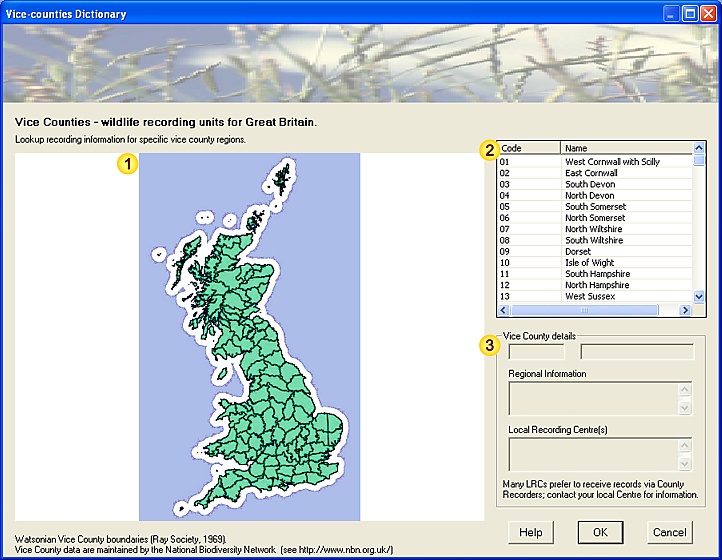
The Vice-counties system
1. The Vice-counties system form:
2. Vice-counties system tools:
| Field | Notes |
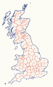
| VC map | Map of the 112 Vice Counties used for wildlife recording in Great Britain. |
| VC list | List of Vice Counties used for wildlife recording in Great Britain (and additionally those
relating to the Channel Islands and Ireland).
Select a Vice County from the list (by clicking on it) to display relevant information (Field ). |
| VC details | Summary information about the selected Vice County (Field ). |
|
| Help | View this help page. |
| OK | Close the dialog. |
| Cancel | Cancel the form. |
3. Additional Notes.
3.1. Vice-counties system
The Vice county system provides a convenient means of sub-dividing the UK and Ireland into manageable regions for compiling wildlife records and habitat information.
|
Figure 1. The Vice County system was first published by Hewett Watson in 1852, dividing England, Scotland and Wales into 112 regions.
Each Vice County is roughly half the size of traditional counties (hence the name), and based on the county borders at that time.
|
3.2. Why use Vice Counties?
For most organisations involved in wildlife recording, the UK as a whole (or even England, Scotland and Wales separately) represents too large an area for compiling records.
Although the (administrative) counties appear to offer a more manageable regional basis for record collation, county borders are quite frequently revised, mainly for political reasons.
This has the unfortunate side-effect of introducing some unusual anomalies into wildlife records, for example;
-
records for regions which pass from one county to another are collated by different Records Centres (or Local Authorities) at different times, fragmenting long-term trends.
-
more surprisingly, some immobile species (such as rare plants) may appear to move from county to county over time as a result of boundary-revisions.
At first sight the Watsonian Vice county system seems to add unnecessary complication to wildlife recording; however for collating wildlife information on a regional basis it offers a number of distinct advantages:
-
VC borders are invariable (dating back to the original specification)
-
VC names are unique and fixed (immune to changes in County names)
-
region sizes are broadly similar
Vice counties are generally referred to by codes (see Table below).
As most naturalists work wholly within one or at most several vice counties, it is unnecessary to remember VC codes for more these.
In general the Vice County system makes it easier to analyse and understand species distributions in the UK, and particularly how these change with time.
This is more evident with static or sedentary species (plants, fungi, etc) than highly mobile species (butterflies and moths, birds, bats), and different recording groups place different emphasis on using the Vice County system.
3.3. Vice Counties of Great Britain and Ireland
| VC code | Coverage | Administrative region |
| 01 | West Cornwall with Scilly | England |
| 02 | East Cornwall | England |
| 03 | South Devon | England |
| 04 | North Devon | England |
| 05 | South Somerset | England |
| 06 | North Somerset | England |
| 07 | North Wiltshire | England |
| 08 | South Wiltshire | England |
| 09 | Dorset | England |
| 10 | Isle of Wight | England |
| 11 | South Hampshire | England |
| 12 | North Hampshire | England |
| 13 | West Sussex | England |
| 14 | East Sussex | England |
| 15 | East Kent | England |
| 16 | West Kent | England |
| 17 | Surrey | England |
| 18 | South Essex | England |
| 19 | North Essex | England |
| 20 | Hertfordshire | England |
| 21 | Middlesex | England |
| 22 | Berkshire | England |
| 23 | Oxfordshire | England |
| 24 | Buckinghamshire | England |
| 25 | East Suffolk | England |
| 26 | West Suffolk | England |
| 27 | East Norfolk | England |
| 28 | West Norfolk | England |
| 29 | Cambridgeshire | England |
| 30 | Bedfordshire | England |
| 31 | Huntingdonshire | England |
| 32 | Northamptonshire | England |
| 33 | East Gloucestershire | England |
| 34 | West Gloucestershire | England |
| 35 | Monmouthshire | Wales |
| 36 | Herefordshire | England |
| 37 | Worcestershire | England |
| 38 | Warwickshire | England |
| 39 | Staffordshire | England |
| 40 | Shropshire | England |
| 41 | Glamorgan | Wales |
| 42 | Breconshire | Wales |
| 43 | Radnorshire | Wales |
| 44 | Carmarthenshire | Wales |
| 45 | Pembrokeshire | Wales |
| 46 | Cardiganshire | Wales |
| 47 | Montgomeryshire | Wales |
| 48 | Merioneth | Wales |
| 49 | Caernarvonshire | Wales |
| 50 | Denbighshire | Wales |
| 51 | Flintshire | Wales |
| 52 | Anglesey | Wales |
| 53 | South Lincolnshire | England |
| 54 | North Lincolnshire | England |
| 55 | Leicestershire with Rutland | England |
| 56 | Nottinghamshire | England |
| 57 | Derbyshire | England |
| 58 | Cheshire | England |
| 59 | South Lancashire | England |
| 60 | West Lancashire | England |
| 61 | South-east Yorkshire | England |
| 62 | North-east Yorkshire | England |
| 63 | South-west Yorkshire | England |
| 64 | Mid-west Yorkshire | England |
| 65 | North-west Yorkshire | England |
| 66 | Durham | England |
| 67 | South Northumberland | England |
| 68 | North Northumberland | England |
| 69 | Westmoreland with Furness | England |
| 70 | Cumberland | England |
| 71 | Isle of Man | Isle of Man |
| 72 | Dumfriesshire | Scotland |
| 73 | Kircudbrightshire | Scotland |
| 74 | Wigtownshire | Scotland |
| 75 | Ayrshire | Scotland |
| 76 | Renfrewshire | Scotland |
| 77 | Lanarkshire | Scotland |
| 78 | Peebleshire | Scotland |
| 79 | Selkirkshire | Scotland |
| 80 | Roxburghshire | Scotland |
| 81 | Berwickshire | Scotland |
| 82 | East Lothian | Scotland |
| 83 | Midlothian | Scotland |
| 84 | West Lothian | Scotland |
| 85 | Fife | Scotland |
| 86 | Stirlingshire | Scotland |
| 87 | West Perthshire | Scotland |
| 88 | Mid Perthshire | Scotland |
| 89 | East Perthshire | Scotland |
| 90 | Angus | Scotland |
| 91 | Kincardineshire | Scotland |
| 92 | South Aberdeenshire | Scotland |
| 93 | North Aberdeenshire | Scotland |
| 94 | Banffshire | Scotland |
| 95 | Moray | Scotland |
| 96 | Easterness | Scotland |
| 97 | Westerness | Scotland |
| 98 | Main Argyll | Scotland |
| 99 | Dunbartonshire | Scotland |
| 100 | Clyde Isles | Scotland |
| 101 | Kintyre | Scotland |
| 102 | South Ebudes | Scotland |
| 103 | Mid Ebudes | Scotland |
| 104 | North Ebudes | Scotland |
| 105 | West Ross | Scotland |
| 106 | East Ross | Scotland |
| 107 | East Sutherland | Scotland |
| 108 | West Sutherland | Scotland |
| 109 | Caithness | Scotland |
| 110 | Outer Hebrides | Scotland |
| 111 | Orkney | Scotland |
| 112 | Shetland | Scotland |
| 113 / C | Channel Islands | Channel Islands |
| H1 | South Kerry | Ireland |
| H2 | North Kerry | Ireland |
| H3 | West Cork | Ireland |
| H4 | Mid-Cork | Ireland |
| H5 | East Cork | Ireland |
| H6 | Waterford | Ireland |
| H7 | South Tipperary | Ireland |
| H8 | Limerick | Ireland |
| H9 | Clare | Ireland |
| H10 | North Tipperary | Ireland |
| H11 | Kilkenny | Ireland |
| H12 | Wexford | Ireland |
| H13 | Carlow | Ireland |
| H14 | Laois | Ireland |
| H15 | South-east Galway | Ireland |
| H16 | West Galway | Ireland |
| H17 | North-east Galway | Ireland |
| H18 | Offaly | Ireland |
| H19 | Kildare | Ireland |
| H20 | Wicklow | Ireland |
| H21 | Dublin | Ireland |
| H22 | Meath | Ireland |
| H23 | Westmeath | Ireland |
| H24 | Longford | Ireland |
| H25 | Roscommon | Ireland |
| H26 | East Mayo | Ireland |
| H27 | West Mayo | Ireland |
| H28 | Sligo | Ireland |
| H29 | Leitrim | Ireland |
| H30 | Cavan | Ireland |
| H31 | Louth | Ireland |
| H32 | Monaghan | Ireland |
| H33 | Fermanagh | Northern Ireland |
| H34 | East Donegal | Ireland |
| H35 | West Donegal | Ireland |
| H36 | Tyrone | Northern Ireland |
| H37 | Armargh | Northern Ireland |
| H38 | Down | Northern Ireland |
| H39 | Antrim | Northern Ireland |
| H40 | Londonderry | Northern Ireland |
One minor drawback of using the Vice county system is that in some cases, as a result of changes to administrative boundaries, vice counties are spread over two or more separate administrative regions.
3.4. References and further Information
NBN Watsonian Vice County information and boundary dataset downloads. (http://www.nbn.org.uk/SpecialPages/WVCB-Download.aspx).
Wikipedia: Vice-county (http://en.wikipedia.org/wiki/Vice-county).
Priority Species information
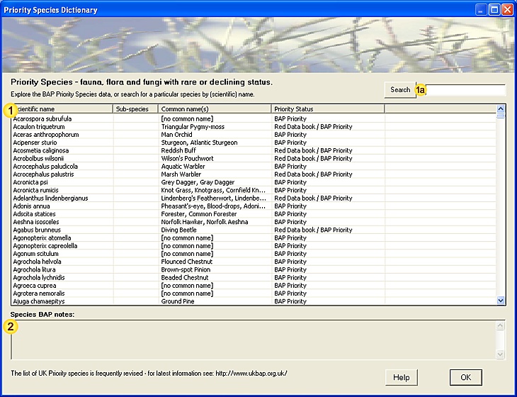
1. The Priority Species form:
2. Priority Species tools:
| Field | Notes |
| Priority Species | List of UK BAP Priority Species (see Note 3.1) .
Click on a column-header to sort list alphabetically by column.
[Listed values: Scientific name; Sub-species (if relevant); Common name(s); Priority Status.] |
| Search Priority Species | Search for a Priority Species by entering the first few letters of the scientific name in the space
provided and using the Search button to locate matching species.
[Species are searched in a forward direction from the current position - press Search repeatedly
to cycle sequentially through all occurrences of the search text in the Species list.] |
| Species notes | Summary information about the selected Priority Species. |
|
| Help | View this help page. |
| OK | Close the dialog. |
3. Additional Notes.
3.1. BAP Priority Species
The list of BAP Priority Species includes all UK species which are considered to be most threatened, or requiring specific conservation action, identified under the UK Biodiversity Action Plan.
A number of criteria are considered in formulating the BAP Priority Species list, including;
-
Species which are threatened internationally
-
Species for which the UK has an international responsibility, and also which have also declined by 25% in the UK
-
Species which have declined by more than 50% in the UK
-
Other factors - for example evidence of extreme threat where numbers are poorly known
The list of UK BAP Priority Species is revised on a regular basis - see http://www.ukbap.org.uk/ for the latest information.
Priority Habitats information
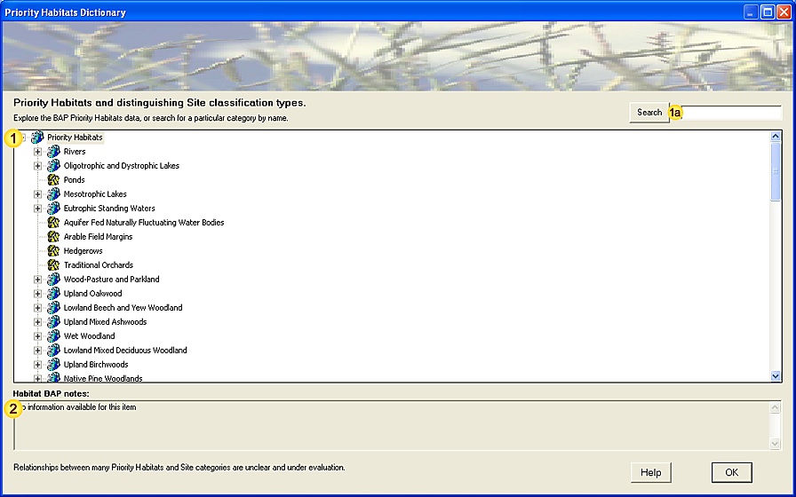
1. The Priority Habitats form:
2. Priority Habitats tools:
| Field | Notes |
| Priority Habitats | A list of UK BAP Priority Habitats (see Note 3.1) and distinguishing Site classification types.
The relationship between Priority Habitats and Site classiciation types is represented by:
-
Priority Habitats list (), which form the top-most levels of the tree.
-
Site Classification types (), which occupy the lowest level of the tree.
Click on the '[+]' symbol to the left of a Priority Habitat name to explore its representative types. |
| Search Priority Habitats | Search for a Priority Habitat (or representative Site classification type) by entering the first few letters
of the name in the space provided and using the Search button to locate matching categories.
[Category names are searched in a forward direction from the current position - press Search repeatedly
to cycle sequentially through all occurrences of the search text in the Priority Habitats list.] |
| Habitat notes | Summary information about the selected Site Classification type.
[Authority proposing the association between Priority Habitat/Site Classification and relevant notes.] |
|
| Help | View this help page. |
| OK | Close the dialog. |
3. Additional Notes.
3.1. BAP Priority Habitats
The list of BAP Priority Habitats includes all UK habitats which are considered to be most threatened, or requiring specific conservation action, identified under the UK Biodiversity Action Plan.
A number of criteria are considered in formulating the BAP Priority Habitats list, including;
-
Habitats for which the UK has an international responsibility
-
Natural and semi-natural habitats in the UK which are considered threatened (rare or declining)
-
Habitats which are important for key species
-
Habitats which are 'functionally critical' for the well-being of certain species - for example overwintering grounds.
The list of UK BAP Priority Habitats is revised on a regular basis - see http://www.ukbap.org.uk/ for the latest information.